Cartoons featured as heavily in the day to day lives of the men and women of 1914 as they do today.
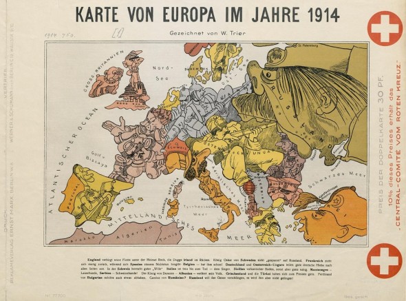
To the right of the image a banner declares that 10% of the proceeds of the map’s sale will go toward the Red Cross. The map is accompanied by a contemporary version of a French woodcut depicting a very different looking Europe of 1870.The images are from the Berlin State Library and are featured as part of the wonderful new project from Europeana, “Europeana, 1914-18” which is marking 100 years since the outbreak of WW1 with a remarkable pan-European pooling of material, from both individuals and institutions, relating to the “Great War”.
First published on the Charley’s War web site
- About the Author
- Latest Posts
John is the founder of downthetubes, launched in 1998. He is a comics and magazine editor, writer, and Press Officer for the Lakes International Comic Art Festival. He also runs Crucible Comic Press.
Working in British comics publishing since the 1980s, his credits include editor of titles such as Doctor Who Magazine and Overkill for Marvel UK, Babylon 5 Magazine, Star Trek Magazine, and its successor, Star Trek Explorer, and more. He also edited the comics anthology STRIP Magazine and edited several audio comics for ROK Comics; and has edited several comic collections and graphic novels, including volumes of “Charley’s War” and “Dan Dare”, and Hancock: The Lad Himself, by Stephen Walsh and Keith Page.
He’s the writer of comics such as Pilgrim: Secrets and Lies for B7 Comics; “Crucible”, a creator-owned project with 2000AD artist Smuzz; and “Death Duty” and “Skow Dogs”, with Dave Hailwood.
Categories: Art and Illustration
 “Captain Scarlet 60” Official Exhibition Items Appeal
  Kev Sutherland helps seek out new comic artists
  Original Don Heck Iron Man art ignites Heritage Auctions sale in $3 million-plus sale
  Phil-Comics eBay Auction Picks